![[Open Data]](https://assets.okfn.org/images/ok_buttons/od_80x15_blue.png)
This project characterized stream temperature regimes in the Bristol Bay, Kodiak Island, Cook Inlet, Copper River, and Prince William Sound regions to better understand thermal habitats for spawning and juvenile salmon. We aggregated 1,691 summertime stream temperature time series from 420 monitoring locations across southwestern and southcentral Alaska and calculated a suite of metrics related to the magnitude, frequency, duration, timing, and variability of stream temperatures. We categorized streams into one of six different thermal regimes using metrics including temperature range, stability, and timing. Thermal regimes represent a gradient of cold to warm habitats with Groups 1 and 6 experiencing the coldest temperatures, and 2, 3, 4, and 5 ranging from colder to warmest. Group 1 had the latest timing of maximum stream temperatures and Group 6 had the most stable stream temperatures. A comparison of stream thermal regimes among regions showed that cold habitats with later timing of maximum temperatures, compared to other thermal regime types, were most common in all regions and that cold stable habitats were most common in the Copper River and Prince William Sound regions. However, all regions included all six thermal regimes described in our classification.
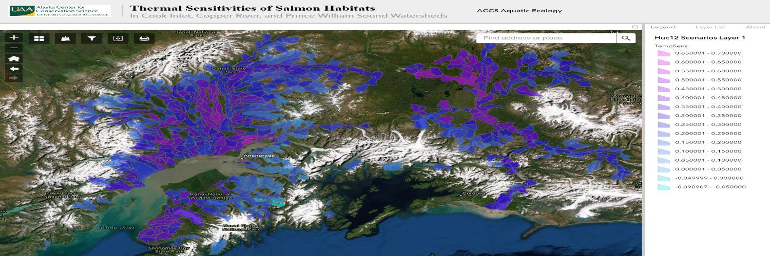
Thermal sensitivity measures how responsive water temperature is to air temperature, which can help reveal the processes that govern stream temperature and how readily water temperature will be affected by air temperature changes. We calculated stream thermal sensitivity (τ) across monitoring sites. Estimated τ was highest in the Cook Inlet and Kodiak regions, followed by Bristol Bay and Copper River, and was lowest in Prince William Sound. We modeled variation in τ using geomorphic, hydrologic, climatic, and landcover covariates. The model was used to map thermal sensitivities across 1,597 salmon streams for high and low scenarios of spring snowpack and summer precipitation. Thermal sensitivities decreased under higher summertime precipitation but changed minimally between years with low and high snowpack. The strongest control on τ was watershed slope, with a lower τ n streams draining steeper watersheds. This result may be due to snowmelt contributions later in the summer period, shorter water residence times, and deeper flowpaths that experience less solar radiation. Chum and pink salmon habitats had the lowest τ, followed by spawning habitats for all species, while rearing habitats and Chinook, coho, and sockeye salmon habitats all had higher τ. Thus, in a warming future, salmon may face tradeoffs between physical habitat preferences for low gradient systems with adaptations for cold water.
Data and Resources
- Assessing Thermal Sensitivities of Salmon Habitats in the Bristol Bay, Kodiak Island, Cook Inlet, Copper River, and Prince William Sound Watershedspdf
Project Completion Report for Alaska Sustainable Salmon Fund Grants 53011...
Download - Zenodo Datasethtml
Five datasets associated with this project have been archived on Zenodo...
Go to resource
| Field | Value |
|---|---|
| Modified | 2024-09-03 |
| Release Date | 2022-05-28 |
| Identifier | a4ca92a8-5986-41cf-a489-5cd5c2bb9cef |
| Spatial / Geographical Coverage Area | POLYGON ((-161.71875 60.235720944616, -151.875 63.856405513681, -143.7890625 62.017662352919, -146.25 58.07351910347, -154.86328125 55.870688097921)) |
| Spatial / Geographical Coverage Location | Cook Inlet, Prince William Sound, Copper River, Bristol Bay, and Kodiak Regions |
| License | |
| Contact Name | Larson, Erin |
| Contact Email | |
| Public Access Level | Public |