![[Open Data]](https://assets.okfn.org/images/ok_buttons/od_80x15_blue.png)
The Alaska Center for Conservation Science (ACCS) at the University of Alaska Anchorage (UAA), in partnership with the Northwest Boreal Landscape Conservation Cooperative (NWB LCC), embarked on a project to map and quantify the human footprint across interior Alaska and northwestern Canada. The goal was to build a seamless dataset that spanned international boundaries by stitching information from state, provincial and territorial entities in order to represent landscape intactness in the boreal ecosystem.
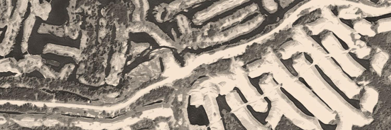
Significant effort was expended on developing a comprehensive dataset defining mining’s footprint across the region. Typically, mines have been depicted by point locations which do not convey their relative sizes or mining activity is represented by claims polygons which overestimate their actual footprints and have a recency bias.
The dataset depicts historical and current ground disturbance resulting from surface mining across Alaska and Northwest Canada. Polygons were initially derived from point locations of historic sites (ARDF - Alaska Resource Data File, US Geological Survey) and then polygons were digitized using best available aerial and satellite imagery. The original dataset was produced in 2017 primarily using year 2013 vintage 2.5-meter resolution SPOT imagery and a hillshade layer derived from an Alaska wide 5-meter IfSAR dataset. This current dataset was updated for Alaskan sites in 2024 using 1-meter imagery of varying vintages ranging from 2016-2023. The dataset primarily includes placer mining sites as well as open pit surface mines. It excludes gravel mining sites or borrow pits.
The mining footprints were intersected with hydrographic datasets (NHD - National Hydrographic Dataset from the USGS in Alaska; and NHN - National Hydrographic Network in Canada) to calculate mapped stream lengths in each footprint polygon. Additionally, the footprints were intersected with the Alaska Department of Fish and Game's Anadromous Waters Catalog (AWC) to calculate known anadromous (primarily salmon bearing) waters within each footprint polygon.
The mining footprint dataset includes over 690 digitized polygons totaling 1200 square kilometers with a mean size of 1.8 sq kms. The footprints have been summarized at the watershed (USGS HUC10 – mean area 688 sq kms) scale across Alaska and at the coarse scale, sub-sub drainage unit (mean area 16,000 sq kms) within Canada. This dataset could help inform decisions regarding natural resource monitoring, identifying potential mitigation or restoration sites, and for conservation planning at watershed scales.
Data and Resources
- Historic Mining Footprint - Factsheetpdf
Two page factsheet summarizing project methods, results, discussion, and...
Download - Web Mapping Application - Mining's Historical Footprint across Alaska and NW Canadahtml
Historic footprint (surface disturbance) of mines across Alaska and portions...
Go to resource - Web Mapping Service - Historic Mining Footprintesri rest
Web mapping service format of dataset representing the historical ground...
Go to resource - Watersheds with largest mapped mining footprints across Alaska and NW Canadapdf
The mining footprint dataset includes over 650 digitized polygons totaling...
Download - Geospatial Dataset (.shp) - Historic Mining Footprint Alaska and NW Canadazip
Over 600 polygons representing the digitized ground disturbance related to...
Download - Geospatial Dataset (.gdb) - Historic Mining Footprint Alaska and NW Canada zip
Over 600 polygons representing the digitized ground disturbance related to...
Download
| Field | Value |
|---|---|
| Modified | 2024-09-03 |
| Release Date | 2019-03-06 |
| Frequency | Irregularly |
| Identifier | bf15f2dd-e59c-4772-aa64-330fd3fa8398 |
| Spatial / Geographical Coverage Area | POLYGON ((-176.8359375 53.182995860087, -176.8359375 71.613481287956, -125.15625 71.613481287956, -125.15625 53.182995860087)) |
| Spatial / Geographical Coverage Location | Alaska, Yukon Territory, northern British Columbia |
| Temporal Coverage | Monday, May 21, 2018 - 00:00 |
| Language | English (United States) |
| License | |
| Author | |
| Contact Name | Geist, Marcus |
| Contact Email | |
| Public Access Level | Public |