![[Open Data]](https://assets.okfn.org/images/ok_buttons/od_80x15_blue.png)

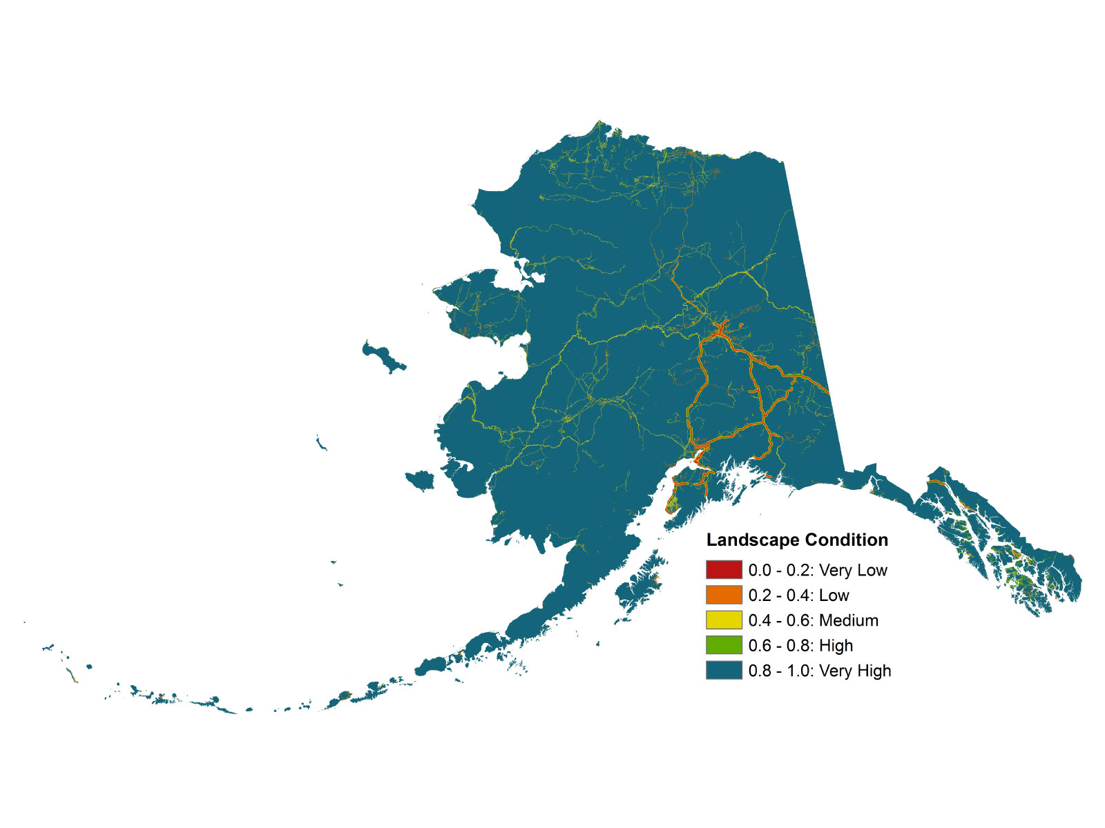
As a measure of potential human impact, the impacts of current anthropogenic development are summarized in a 60 x 60 m grid by the landscape condition model (LCM). The LCM weighs the relative influence of different types of human footprints based on factors like permanence, nature of the activity, etc. Permanent human modification is weighted the highest, while temporary use receive less weight. Intensive land uses like mining are also weighted higher than less intensive land uses like trails. These weights are summed across the landscape and coalesced into a single surface identifying how impacted a given area is due to human modification. Categories of human impacts included in this analysis are transportation infrastructure, urban and industrial development, and invasive species. Distance decay values are assigned to each impact such that the impact declines with increasing distance from infrastructure. Human impacts of each type are merged according to MIN rules to create a final dataset. This analysis is intended to identify the current level of human impact in the state. The output for landscape condition is a relative scale from 1 to 5, with values of 5 representing "Very High" landscape condition and values of 1 representing "Very Low" landscape condition.
 [AK Landscape
Data and Resources
- Landscape Condition in Alaskazip
As a measure of potential human impact, the impacts of current anthropogenic...
Download - Development of a Landscape Integrity dataset for the Alaska Crucial Habitat Assessment Toolpdf
As a measure of potential human impact, the impacts of current anthropogenic...
Download - Landscape Condition in Alaska circa 2014html
The online web map depicts landscape condition for the entire state of...
Go to resource
| Field | Value |
|---|---|
| Modified | 2019-05-16 |
| Release Date | 2018-02-26 |
| Frequency | Irregularly |
| Identifier | 98ba6a88-f122-4a95-8ee8-ffbe8c77f288 |
| Spatial / Geographical Coverage Area | POLYGON ((-134.9560546875 54.408540933774, -133.1982421875 54.536222879457, -130.1220703125 54.587184129624, -129.19921875 55.418882004224, -129.7705078125 56.379699960755, -130.7373046875 56.791101739393, -132.1435546875 57.788428763956, -133.6376953125 59.301655008315, -134.384765625 59.879979345032, -135.6591796875 60.20912203063, -136.6259765625 59.990058250948, -137.8564453125 60.187281158597, -138.515625 60.621344751797, -139.482421875 60.814789886892, -140.09765625 60.921756868235, -140.009765625 64.747774862031, -140.009765625 69.92417286463, -141.4599609375 70.297915091061, -143.1298828125 70.679515685606, -146.1181640625 70.766562816169, -149.150390625 71.26686194455, -151.5673828125 71.50531567386, -153.8525390625 71.616513246162, -156.181640625 71.809557536767, -157.6318359375 71.809557536767, -158.90625 71.588774508537, -161.9384765625 70.867640903458, -164.267578125 70.342312766531, -164.7509765625 69.711917319414, -166.2451171875 69.466707562874, -167.8271484375 69.171837509851, -167.9150390625 68.761768880405, -168.0908203125 68.19758249902, -166.7724609375 67.484916011385, -166.025390625 67.026195665606, -167.16796875 66.663315685915, -168.57421875 66.064304452645, -168.98620605469 66.015785368551, -169.03015136719 65.487905213604, -169.013671875 65.175535826461, -171.298828125 64.236836105448, -172.30682373047 63.979575849425, -172.79296875 63.166135888569, -173.671875 61.889166927012, -174.22119140625 60.576174726269, -173.2763671875 59.467407941837, -171.5625 58.631216643425, -171.5625 57.539416794475, -170.595703125 55.67758441109, -171.2548828125 54.048907938385, -175.341796875 52.951120163682, -181.318359375 53.056898069445, -186.2841796875 53.686135238171, -187.7783203125 53.634053516459, -188.701171875 52.871616566799, -187.55859375 52.203398695209, -186.064453125 51.47026338272, -181.93359375 50.697327508283, -177.626953125 50.418143877306, -173.4521484375 50.947180178057, -170.2001953125 51.634214543026, -167.51953125 52.310997483367, -161.3232421875 53.555810223595, -157.236328125 54.714308778521, -153.4130859375 55.468734807297, -151.34765625 56.646412233912, -149.94140625 57.998638149375, -149.150390625 58.461383753198, -144.404296875 59.008749041335, -141.328125 58.918118925098, -139.5703125 58.369317032861, -138.2958984375 57.671114003279, -137.2412109375 56.476903421268, -136.23046875 55.343984657871, -135.9228515625 54.89161591461, -135.9228515625 54.89161591461)) |
| Spatial / Geographical Coverage Location | Alaska, USA |
| Language | English (United States) |
| License | |
| Granularity | 60 m |
| Author | |
| Contact Name | Jamie Trammell |
| Contact Email | |
| Public Access Level | Public |