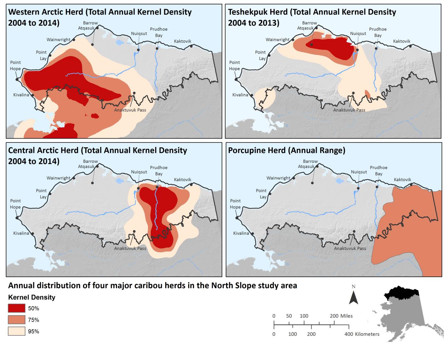
The Alaska Department of Fish and Game maintains radio collar and satellite telemetry data for the Western Arctic, Teshekpuk, and Central Arctic herds. ADF&G summarized the telemetry data as kernel densities to delineate the total annual distributions of the three caribou herds. Collar location data points were extracted from the entire annual cycle from 2004 to 2013 for the Teshekpuk Herd and 2004 to 2014 for the Western Arctic and Central Arctic herds. For each day, the location point closest to noon was selected, with no more than one location every six days per individual. The resulting set of points served as the input for kernel density calculations. Kernel density was calculated for individual years and the results were summed to capture annual variability in caribou habitat use. Through a data sharing agreement between ADF&G and AKNHP, these kernel densities were available for the North Slope REA. Kernel densities are based on the daily positions of a small subset of individuals from the total herd. For example, no more than 0.03% of the Western Arctic Herd has been collared. No kernel density or radio/satellite-collar data was available for the Porcupine Herd because of shared management with Canada. The 1983 to 2001 annual range of the herd reported in Griffith et al. (2002) was digitized for this assessment. The calving range of the Porcupine Herd was digitized from the 1983 to 2001 calving range reported in Griffith et al. 2002. All other seasonal range polygons were hand-delineated based on a variety of past reports and datasets.
Data and Resources
- Range for the Western Arctic Caribou Herdzip
The Alaska Department of Fish and Game (ADF&G) maintains radio collar...
Download - Range for the Teshekpuk Herdzip
The Alaska Department of Fish and Game (ADF&G) maintains radio collar...
Download - Range for the Central Arctic Herdzip
The Alaska Department of Fish and Game (ADF&G) maintains radio collar...
Download - Range for the Porcupine Herd zip
The Alaska Department of Fish and Game (ADFG) maintain radio collar and...
Download
| Field | Value |
|---|---|
| Modified | 2025-10-03 |
| Release Date | 2018-02-06 |
| Frequency | Irregularly |
| Identifier | 1d2b5777-474a-45dd-a894-10867b3461fd |
| Spatial / Geographical Coverage Area | POLYGON ((-140.03173828125 67.495956708439, -140.09765625 70.06839376023, -142.3828125 70.54228811331, -146.6015625 70.832953109413, -153.017578125 71.541438942045, -156.357421875 71.872472408074, -158.642578125 71.541438942045, -162.685546875 70.832953109413, -164.1796875 70.06839376023, -165.234375 69.614076059913, -167.16796875 69.243498967199, -167.87109375 68.386031663986, -165.498046875 67.272042673995, -140.009765625 67.156097269634, -141.35009765625 67.1742172779, -140.009765625 67.156097269634, -140.04272460938 67.344093089357)) |
| Spatial / Geographical Coverage Location | North Slope, Alaska, USA |
| Language | English (United States) |
| License | |
| Author | |
| Data Dictionary | |
| Public Access Level | Public |

![[Open Data]](https://assets.okfn.org/images/ok_buttons/od_80x15_blue.png)
