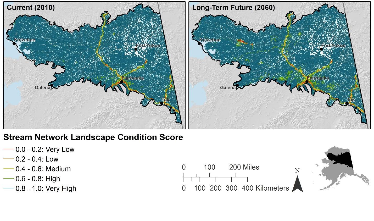
The current (2015) and long-term future (2060) landscape condition model (LCM) was modified to develop condition scores for both the stream network and individual 6th-level hydrologic units. Landscape condition is a measurement of the impact of the human footprint on a landscape. Human modifications were categorized into different levels of impact (site impact scores) based on the current state of knowledge about the impacts of specific human land uses. An artificial stream network was calculated from the USGS National Elevation Dataset 2 Arc Second Digital Elevation Model using TauDEM. The flow direction grid and LCM grids were used to create a condition-weighted contributing area grid that summed condition scores upstream of each cell in the synthetic stream network. The resulting sums were divided by the total accumulation (number of upstream cells per individual cell) of each cell to create mean watershed condition scores along the stream network. Mean watershed condition scores only represented those parts of the watershed within the area since the extent of input data ended at the boundary. Current and long-term future (2060) condition scores for the stream network were classified into five equal intervals and summarized across the area.
40 files in this archive
- CYR_AE_C_StreamNetwork_LandscapeCondition.cpg
- CYR_AE_C_StreamNetwork_LandscapeCondition.dbf
- CYR_AE_C_StreamNetwork_LandscapeCondition.lyr
- CYR_AE_C_StreamNetwork_LandscapeCondition.prj
- CYR_AE_C_StreamNetwork_LandscapeCondition.sbn
- CYR_AE_C_StreamNetwork_LandscapeCondition.sbx
- CYR_AE_C_StreamNetwork_LandscapeCondition.shp
- CYR_AE_C_StreamNetwork_LandscapeCondition.shp.xml
- CYR_AE_C_StreamNetwork_LandscapeCondition.shx
- CYR_AE_C_StreamNetwork_LandscapeCondition.xml
- CYR_AE_C_StreamNetwork_LandscapeCondition6thLevelHydrologicUnits.cpg
- CYR_AE_C_StreamNetwork_LandscapeCondition6thLevelHydrologicUnits.dbf
- CYR_AE_C_StreamNetwork_LandscapeCondition6thLevelHydrologicUnits.lyr
- CYR_AE_C_StreamNetwork_LandscapeCondition6thLevelHydrologicUnits.prj
- CYR_AE_C_StreamNetwork_LandscapeCondition6thLevelHydrologicUnits.sbn
- CYR_AE_C_StreamNetwork_LandscapeCondition6thLevelHydrologicUnits.sbx
- CYR_AE_C_StreamNetwork_LandscapeCondition6thLevelHydrologicUnits.shp
- CYR_AE_C_StreamNetwork_LandscapeCondition6thLevelHydrologicUnits.shp.xml
- CYR_AE_C_StreamNetwork_LandscapeCondition6thLevelHydrologicUnits.shx
- CYR_AE_C_StreamNetwork_LandscapeCondition6thLevelHydrologicUnits.xml
- CYR_AE_L_StreamNetwork_LandscapeCondition.cpg
- CYR_AE_L_StreamNetwork_LandscapeCondition.dbf
- CYR_AE_L_StreamNetwork_LandscapeCondition.lyr
- CYR_AE_L_StreamNetwork_LandscapeCondition.prj
- CYR_AE_L_StreamNetwork_LandscapeCondition.sbn
- CYR_AE_L_StreamNetwork_LandscapeCondition.sbx
- CYR_AE_L_StreamNetwork_LandscapeCondition.shp
- CYR_AE_L_StreamNetwork_LandscapeCondition.shp.xml
- CYR_AE_L_StreamNetwork_LandscapeCondition.shx
- CYR_AE_L_StreamNetwork_LandscapeCondition.xml
- CYR_AE_L_StreamNetwork_LandscapeCondition6thLevelHydrologicUnits.cpg
- CYR_AE_L_StreamNetwork_LandscapeCondition6thLevelHydrologicUnits.dbf
- CYR_AE_L_StreamNetwork_LandscapeCondition6thLevelHydrologicUnits.lyr
- CYR_AE_L_StreamNetwork_LandscapeCondition6thLevelHydrologicUnits.prj
- CYR_AE_L_StreamNetwork_LandscapeCondition6thLevelHydrologicUnits.sbn
- CYR_AE_L_StreamNetwork_LandscapeCondition6thLevelHydrologicUnits.sbx
- CYR_AE_L_StreamNetwork_LandscapeCondition6thLevelHydrologicUnits.shp
- CYR_AE_L_StreamNetwork_LandscapeCondition6thLevelHydrologicUnits.shp.xml
- CYR_AE_L_StreamNetwork_LandscapeCondition6thLevelHydrologicUnits.shx
- CYR_AE_L_StreamNetwork_LandscapeCondition6thLevelHydrologicUnits.xml

